Hello there, curious minds! Today we have a journey through the intriguing world of GeoJSON, a brilliant little invention that has revolutionised the way we interact with geospatial data. Grab your virtual hard hat, because we’re about to dig deep into the history, creation, resources, and research involving this captivating data format.
Who Created GeoJSON?
Our journey begins with the birth of GeoJSON. GeoJSON is the brainchild of a cooperative effort led by Howard Butler, Martin Daly, and Allan Doyle. They kicked off the initiative back in 2007, rallying an open community of geospatial professionals to contribute and collaborate on the project. Thanks to this collaborative spirit, the GeoJSON specification was born.
A Brief Tryst with History
The tale of GeoJSON is a fascinating one, starting with a need and ending with a widespread adoption across the globe. Let’s have a quick glance at its timeline:
- 2007: The inception of GeoJSON began with the formation of an online working group. Their shared objective was to define a simple and open format for representing geographic features.
- 2008: GeoJSON 1.0 was officially released to the world, a simple yet powerful specification that allowed for encoding a wide variety of geographic data structures.
- 2016: Nearly a decade after its initial inception, the Internet Engineering Task Force (IETF) officially published GeoJSON as a standard in the Request for Comments (RFC) 7946. This significant event catapulted GeoJSON into the mainstream.
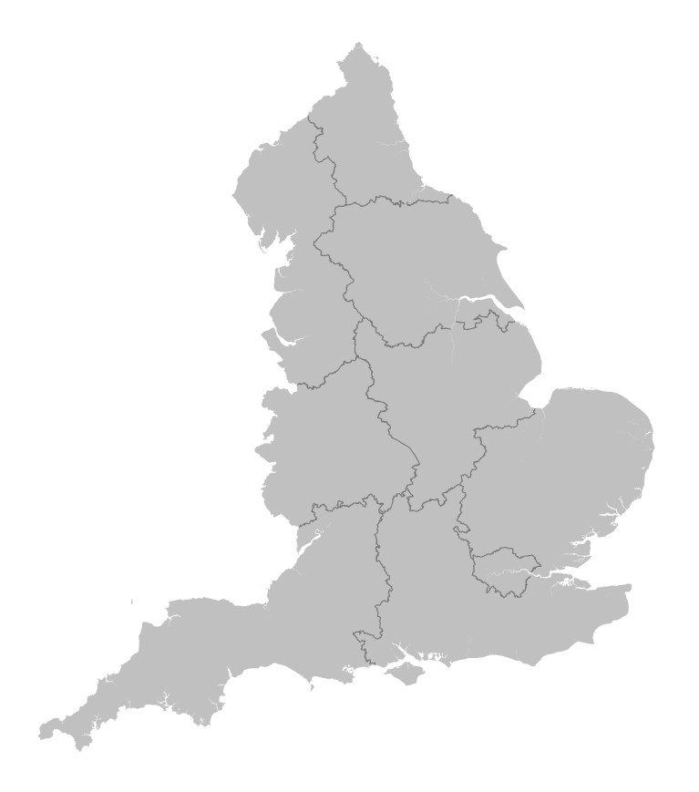
Image above – Example of a rendered GEOJSON map – Credit: https://martinjc.github.io/UK-GeoJSON/
Delving Into GeoJSON
GeoJSON is a geospatial data interchange format based on JavaScript Object Notation (JSON). JSON is a popular format for exchanging data due to its readability and easy use with modern programming languages. GeoJSON extends JSON by introducing geographical features.
GeoJSON encodes geographic features and their attributes as part of a JavaScript object. These geographic features can include points (like a city’s location), lines (like roads), and polygons (like the boundaries of a country). GeoJSON doesn’t just handle simple features though, it’s also capable of multi-part collections of these features (think of the chain of Hawaiian Islands as an example).
Resources for Learning and Exploring GeoJSON
For those interested in diving deeper into GeoJSON, a wealth of resources exist. Here are a few to get you started:
- GeoJSON.org: This website is the de facto source of all things GeoJSON, including the official specification. It’s the best place to start your journey. Visit GeoJSON.org
- RFC 7946: The IETF’s official publication of GeoJSON as a standard is an invaluable resource for those seeking a detailed understanding of GeoJSON. Read RFC 7946
- GeoJSONLint: This is an online tool that lets you validate your GeoJSON code, ensuring it follows the GeoJSON specification. Try GeoJSONLint
- Various Online Tutorials: There are plenty of online resources offering tutorials on GeoJSON, from beginners to advanced. Some of the popular ones include resources from W3Schools, Mozilla Developer Network, and Leaflet’s interactive map tutorials.
Groundbreaking Research
As with any significant technological innovation, GeoJSON has sparked a wealth of research. Its flexibility and interoperability have led to its adoption in numerous fields such as environmental science, urban planning, transportation, and more.
For instance, GeoJSON has played a critical role in disaster response and management. Researchers have used it to quickly disseminate geospatial data during crises, aiding in efficient and effective response efforts.
Furthermore, its widespread use in web-based applications has driven advancements in interactive mapping. Developers use GeoJSON to create rich, interactive maps that can be easily shared and embedded in web pages.
Conclusion – GeoJSON has come a long way
From a humble beginning in 2007 to becoming an industry standard, GeoJSON has come a long way. It continues to transform the way we represent, exchange, and interact with geographical data, enabling endless possibilities for research and application. So, whether you’re a budding geospatial enthusiast or a seasoned pro, GeoJSON is a valuable tool worth exploring.
This exploration of GeoJSON hopefully provides a handy guide, explaining what it is, who created it, and how to learn more about it. We’ve taken a brief dive into the rich world of GeoJSON, but there’s always more to learn, more to discover, and more to invent.
References
- Butler, H., Daly, M., Doyle, A., Gillies, S., Schaub, T., & Schmidt, C. (2008). The GeoJSON Format Specification.
- IETF (2016). The GeoJSON Format. RFC 7946.
Happy exploring, and remember – in the world of GeoJSON, the world is your oyster!