The city of Manchester has long been a significant centre of commerce, culture, and industry in the United Kingdom. As such, an efficient postal system has been essential to its ongoing growth and development. In the early 20th century, Manchester adopted the postal district system model pioneered in London, using a combination of letters and numbers to designate distinct districts within the city. This article offers a comprehensive look at Manchester’s postcodes and districts, delving into their history, structure, and impact on the city’s postal services.
The Origins of Manchester’s Postal District System
Early Adoption and Expansion
Inspired by the successful implementation of the postal district system in London, Manchester adopted a similar approach in the early 20th century. The city was divided into distinct districts, each designated by the letter ‘M’ followed by a number (e.g., M1, M2, M3). This system allowed Manchester to streamline mail sorting and delivery, catering to its rapidly growing population during the Industrial Revolution.
Ongoing Adaptation
Manchester’s postal district system has continued to evolve over the years to accommodate the city’s growth and changing needs. The expansion of the city and its population necessitated the ongoing development of its postal codes, with new alphanumeric combinations added to improve the accuracy and efficiency of mail delivery services.
Structure of Manchester’s Postal Districts
Central Manchester
Central Manchester is home to several key districts, each with its own unique postcode. These include:
- M1: This district covers the city centre, including Piccadilly, the Northern Quarter, and Ancoats. As the heart of Manchester, this area is known for its bustling shopping centres, vibrant nightlife, and cultural attractions.
- M2: This district encompasses the central business district, including Deansgate and Spinningfields. M2 is home to many of Manchester’s corporate headquarters, legal firms, and financial institutions.
- M3: Covering the western part of the city centre, M3 includes the Castlefield area, known for its historical sites, picturesque canals, and repurposed industrial buildings.
Greater Manchester
Beyond the city centre, Manchester’s postal districts extend to include various suburbs and neighbouring towns. Some of these include:
- M4: This district covers the Ancoats and Northern Quarter areas, which have undergone significant redevelopment in recent years. M4 is now known for its creative industries, independent businesses, and trendy bars and restaurants.
- M20: Home to the popular residential neighbourhoods of Didsbury and Withington, M20 is an attractive destination for families and young professionals alike. This district is known for its green spaces, charming architecture, and lively local communities.
- M32: This district includes the towns of Stretford and Trafford Park, with the latter being a significant industrial and business hub in the Greater Manchester area.
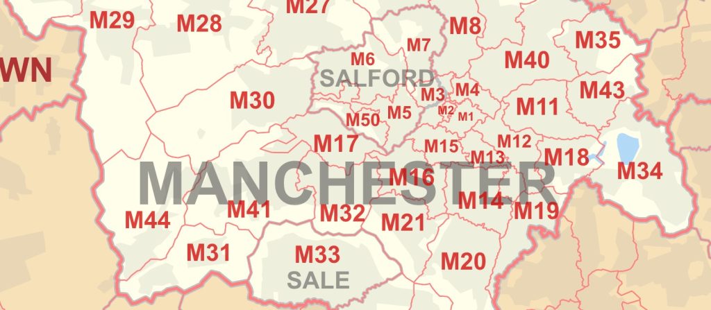
Greater Manchester Postcode (Outcodes) Districts List
This table provides a comprehensive overview of the various postcode districts in Greater Manchester, United Kingdom. It outlines the specific areas covered within each postcode district, as well as the corresponding local authority areas.
| Postcode Outcodes | Coverage | Local authorities |
|---|---|---|
| M1 | Piccadilly, City Centre, Market Street | Manchester |
| M2 | Deansgate, City Centre | Manchester |
| M3 | City Centre, Deansgate, Castlefield | Manchester |
| M3 | Blackfriars, Greengate, Trinity | Salford |
| M4 | Ancoats, Northern Quarter, Strangeways | Manchester |
| M5 | Ordsall, Seedley, Weaste, University | Salford |
| M6 | Pendleton, Irlams o’ th’ Height, Langworthy, Seedley, Charlestown | Salford |
| M7 | Higher Broughton, Cheetwood, Lower Broughton, Kersal | Salford |
| M8 | Crumpsall, Cheetham Hill | Manchester |
| M9 | Harpurhey, Blackley | Manchester |
| M11 | Clayton, Openshaw, Beswick | Manchester |
| M12 | Ardwick, Longsight, Chorlton-on-Medlock | Manchester |
| M13 | Ardwick, Longsight, Chorlton-on-Medlock | Manchester |
| M14 | Fallowfield, Moss Side, Ladybarn, Rusholme, Victoria Park, Longsight | Manchester |
| M15 | Hulme, Manchester Science Park, Old Trafford | Manchester, Trafford |
| M16 | Firswood, Old Trafford, Whalley Range, Moss Side | Manchester, Trafford |
| M17 | Trafford Park, The Trafford Centre | Trafford |
| M18 | Abbey Hey, Gorton | Manchester |
| M19 | Levenshulme, Burnage | Manchester, Stockport |
| M20 | Didsbury, Withington | Manchester |
| M21 | Chorlton-cum-Hardy, Barlow Moor | Manchester |
| M22 | Wythenshawe, Northenden, Sharston Industrial Area | Manchester |
| M23 | Baguley, Brooklands, Roundthorn Industrial Estate | Manchester, Trafford |
| M24 | Middleton, Alkrington, Chadderton | Rochdale, Oldham |
| M25 | Prestwich, Sedgley Park, Simister | Bury |
| M26 | Radcliffe, Stoneclough | Bury, Bolton |
| M27 | Swinton, Clifton, Pendlebury, Wardley, Agecroft | Salford |
| M28 | Worsley, Walkden, Boothstown, Mosley Common, Wardley Industrial Estate | Salford, Wigan |
| M29 | Tyldesley, Astley | Wigan |
| M30 | Eccles, Monton, Peel Green, Winton, Patricroft, Barton-upon-Irwell, Ellesmere Park | Salford |
| M31 | Carrington, Partington | Trafford |
| M32 | Stretford | Trafford |
| M33 | Sale, Brooklands | Trafford |
| M34 | Denton, Audenshaw | Tameside |
| M35 | Failsworth | Oldham |
| M38 | Little Hulton | Salford |
| M40 | Collyhurst, Miles Platting, Moston, New Moston, Newton Heath | Manchester |
| M41 | Urmston, Davyhulme, Flixton, Trafford Park | Trafford |
| M43 | Droylsden | Tameside |
| M44 | Irlam, Cadishead | Salford |
| M45 | Whitefield | Bury |
| M46 | Atherton | Wigan, Bolton |
| M50 | Salford Quays, MediaCityUK | Salford |
| M60 | Large businesses and PO Box | Salford |
| M90 | Manchester Airport | Manchester |
The Impact of Manchester’s Postal District System
The adoption of the postal district system has had a lasting impact on Manchester’s postal services, as well as the city itself. The streamlined process for sorting and delivering mail has contributed to the efficiency of the city’s postal network, while the alphanumeric codes have become an integral part of Manchester’s identity.
Moreover, the postal district system has enabled Manchester to better manage its urban growth and development. The clear delineation of districts has facilitated city planning, allowing officials to better allocate resources and monitor demographic changes.
The implementation of the postal district system in Manchester has been instrumental in enhancing the city’s postal services and supporting its ongoing growth and development. The clear and organised structure of Manchester’s postcodes and districts has allowed for more.