Calculating distances on Earth’s surface is an essential component in a wide array of industries, including navigation, cartography, and geographic information systems (GIS). With the ever-growing need for precise and reliable measurements, several methods have emerged for tackling these calculations, each boasting its unique set of pros and cons.
Among the most widely used and trusted techniques are the Haversine formula, Vincenty formula, and ellipsoidal Earth model. The choice of method is often influenced by factors such as the intended application and the desired level of accuracy. In this article, we will delve into the intricacies of these three prominent methods, examining their foundational principles, inherent limitations, and ideal use cases.
The Haversine formula, Vincenty formula, and ellipsoidal Earth model each offer a distinct approach to solving the complex problem of measuring distances on our planet’s surface. While the Haversine formula simplifies the task by assuming Earth is a perfect sphere, the Vincenty formula and ellipsoidal Earth model take a more nuanced approach, factoring in the Earth’s true shape as an oblate spheroid. This distinction plays a critical role in determining the most suitable method for a particular application, as it directly impacts the accuracy and computational complexity of the calculations.
In this comprehensive analysis, we will explore the origins and mathematical foundations of each method, as well as the various factors that influence their performance, such as accuracy, complexity, and computational efficiency. Furthermore, we will evaluate their respective limitations and discuss their ideal use cases, helping you make an informed decision when choosing a method for your specific needs.
By gaining a thorough understanding of the Haversine formula, Vincenty formula, and ellipsoidal Earth model, you can confidently select the most appropriate approach for calculating distances on Earth’s surface. This knowledge will not only contribute to the success of your project but also help you navigate the ever-evolving landscape of geospatial technologies and applications.
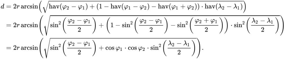
Haversine Formula: An Overview
The Haversine formula is a well-known and widely used method for calculating the great-circle distance between two points on Earth’s surface, given their latitude and longitude coordinates. It works by assuming that the Earth is a perfect sphere and uses trigonometric functions like sine and cosine to account for Earth’s curvature when calculating distances.
Advantages:
- Simple and easy to implement.
- Accurate enough for most applications, especially for small to medium distances.
Limitations:
- Assumes Earth is a perfect sphere, which can result in slight inaccuracies, particularly for longer distances.
Use Cases:
- Navigation systems, location-based services, and other applications where high precision is not critical.
Vincenty Formula: An Overview
The Vincenty formula, developed by Thaddeus Vincenty in 1975, is a more complex method for calculating distances on an ellipsoidal Earth model. It takes into account the Earth’s flattening, resulting in a higher level of accuracy compared to the Haversine formula.
Advantages:
- Provides a more accurate solution for distance calculations, especially for long distances.
- Takes into account the Earth’s true shape as an oblate spheroid.
Limitations:
- More complex and computationally intensive than the Haversine formula.
- Convergence issues can occur in some cases, particularly near the poles or antipodal points.
Use Cases:
- Applications that require high-precision distance calculations, such as aviation, surveying, and cartography.
Ellipsoidal Earth Model: An Overview
The ellipsoidal Earth model, also known as the geodetic model, is a mathematical representation of the Earth’s shape as an oblate spheroid. The model is typically used in conjunction with other formulas, like the Vincenty formula or the geodesic method, to calculate accurate distances on Earth’s surface.
Advantages:
- Represents the Earth’s shape more accurately than a spherical model.
- Provides a foundation for high-precision distance calculations.
Limitations:
- More complex than the Haversine formula, requiring additional data and computations.
- May require specialized algorithms or libraries for implementation.
Use Cases:
- High-precision distance calculations in surveying, mapping, and geodesy.
Comparison: Haversine Formula vs. Vincenty Formula vs. Ellipsoidal Earth Model
Accuracy:
- The haversine formula is accurate for short to medium distances but less precise for long distances due to its spherical assumption.
- Vincenty formula and ellipsoidal Earth model offer higher accuracy, particularly for long distances, as they account for the Earth’s true shape.
Complexity:
- The haversine formula is the simplest and easiest to implement, making it ideal for basic applications.
- Vincenty formula and ellipsoidal Earth model are more complex and computationally intensive, requiring specialized knowledge and algorithms for implementation.
Use Cases:
- The haversine formula is suitable for applications where high precision is not critical, such as navigation systems and location-based services.
- Vincenty formula and ellipsoidal Earth model are best suited for high-precision distance calculations in industries such as aviation, surveying, cartography, and geodesy, where a higher level of accuracy is essential.
Performance:
- The haversine formula, being simpler, is generally faster and requires fewer computational resources.
- Vincenty formula and ellipsoidal Earth model, while more accurate, can be slower and more resource-intensive due to their complexity.
Limitations:
- Haversine’s formula’s primary limitation is its assumption of Earth as a perfect sphere, which can lead to inaccuracies for longer distances.
Vincenty formula can face convergence issues near the poles or antipodal points. - The Ellipsoidal Earth model may necessitate specialized algorithms or libraries for implementation, adding complexity to the development process.
Selecting the Ideal Method for Your Application
When choosing between the Haversine formula, Vincenty formula, and ellipsoidal Earth model for calculating distances on Earth’s surface, it is crucial to consider the specific requirements and goals of your application. If your primary concerns are simplicity and speed, and high precision is not essential, the Haversine formula may be the most appropriate solution. However, if your project demands a higher degree of accuracy, particularly over longer distances, the Vincenty formula or a method based on the ellipsoidal Earth model may be the more suitable choice.
To make an informed decision, it is essential to thoroughly understand the advantages and limitations of each method. The Haversine formula’s simplicity makes it an attractive option for many applications, but its assumption of Earth as a perfect sphere can lead to inaccuracies over longer distances. In contrast, the Vincenty formula and ellipsoidal Earth model take the Earth’s true shape into account, providing higher precision at the cost of increased complexity and computational demands.
By carefully considering the unique characteristics of each method, you can select the most appropriate approach for your distance calculation needs, ensuring the success of your project. In turn, this knowledge will empower you to navigate the complex world of geospatial technologies with confidence and make well-informed decisions that will ultimately benefit your work and the industries it serves.